
Smith County ZIP Code Coverage
The Smith County ZIP code directory starts with postal geography, not a roster. These ZIPs are documented for Smith County communities in the USPS and county postal references reviewed for this research. A ZIP can include territory outside the county or city in its mailing name, so use the USPS address tool before attaching a particular parcel or record to an area.
| ZIP code | Smith County area | Post office or station | Postal caution |
|---|---|---|---|
| 75701 | Tyler east, central, and Azalea-area delivery | Tyler and Azalea stations | USPS groups it with 75707. |
| 75702 | Tyler central, west, and main postal area | Tyler Post Office, 2100 W. Martin Luther King Blvd. | USPS groups it with 75704–06 and 75708. |
| 75703 | South Tyler | South Tyler Annex, 6722 S. Broadway Ste. 100 | Extends into south-county growth; check city limits. |
| 75704 | Tyler west and southwest delivery | Tyler and southeast-area stations | Postal naming can differ from neighborhood naming. |
| 75705 | Tyler postal delivery, PO Box, or special routes | Tyler postal office | Use an address check; it is not a neighborhood polygon. |
| 75706 | Tyler rural and north delivery | Tyler postal office | County-edge variation calls for a street-level check. |
| 75707 | East and southeast Tyler, Lake Tyler communities | Azalea and area stations | Postal city can include county-side developments. |
| 75708 | Tyler north and east delivery | Tyler Post Office grouping | USPS groups it with 75702. |
| 75709 | Southwest Tyler | Tyler postal office | USPS groups it with 75703. |
| 75710 | Tyler PO Box or special postal use | Tyler postal office | Not a simple household area. |
| 75711 | Tyler PO Box or special postal use | Tyler postal office | Verify with the USPS mode for the address. |
| 75712 | Tyler PO Box or special postal use | Tyler postal office | Verify with the USPS mode for the address. |
| 75713 | Tyler institutional or special delivery | Tyler postal office | Exact static USPS coverage was not exposed. |
| 75750 | Arp | Arp Post Office | Arp is a Smith County city. |
| 75757 | Bullard | Bullard Post Office | Bullard straddles Smith and Cherokee counties. |
| 75762 | Flint and nearby south or east county | Flint Post Office, FM 346 | Postal area can cross city or county lines. |
| 75771 | Lindale and Hideaway area | Lindale Post Office, 507 S. Main | Postal convention differs by address. |
| 75789 | Troup | Troup Post Office | Smith and Cherokee area context requires parcel verification. |
| 75791 | Whitehouse | Whitehouse Post Office, 1114 TX-110 N. | City limits and ZIP boundaries are not identical. |
| 75792 | Winona | Winona Post Office | Verify the street for rural and city delivery. |
| 75798 | Tyler Junior College | Institutional Tyler delivery | Special-use ZIP, not a general household area. |
| 75799 | University of Texas at Tyler | Institutional Tyler delivery | Special-use ZIP, not a general household area. |
The USPS ZIP Lookup provides By Address, By City and State, and Cities by ZIP modes. Its standardized result can verify postal delivery information, but USPS expressly says that a ZIP result does not confirm that a person or organization is at the address.
Compare Smith County Tyler ZIPs
Tyler is the county’s largest postal cluster, but its ZIP families should not be read as municipal boundaries. The documented USPS grouping connects 75701 with 75707, 75702 with 75704 through 75706 and 75708, and 75703 with 75709. The 75710 through 75713 range adds PO Box, special-delivery, or institutional patterns that need address-level verification before any record search is narrowed.
For a Smith County postal search, keep the postal city separate from the situs address. An unincorporated area can use a Tyler mailing city, and a city record can have a different custodian from the county record. The actual parcel, city-limit check, and legal description resolve that conflict better than the ZIP alone.
Note: Use the ZIP to begin an address check, then retain the standardized street address and parcel jurisdiction for the next record system.
Compare Smith County Community ZIPs
Arp, Bullard, Flint, Lindale, Troup, Whitehouse, and Winona give the Smith County postal search its countywide reach beyond Tyler. The postal areas are useful for identifying the community associated with an address, but municipal and county authority still depends on the exact parcel. Bullard and Troup have Smith and Cherokee county context. Lindale, Whitehouse, Winona, and Flint each combine postal, municipal, and unincorporated-area patterns that can diverge.
SCAD appraisal boundaries cover Smith County, while permits, zoning, and code work can be municipal or county matters. A local address can therefore carry a community ZIP while its planning record sits under a different authority. Use the Smith County Map Site to check the parcel’s map context before selecting a city or county office.
Separate Smith County Institutional ZIPs
Two Tyler ZIP codes need special handling. ZIP 75798 is associated with Tyler Junior College, and 75799 is associated with the University of Texas at Tyler. They are institutional or unique-delivery ZIPs, not general neighborhood areas. A matching postal code does not describe a household, and a community or school record should not be converted into a personal residence claim.
PO Box and special-use Tyler ZIPs also need the same caution. Use a full physical address with USPS when an official record needs a delivery check, and rely on the situs or legal description for the property record.
Find Smith County ZIP Residents
ZIP searching works differently across Smith County systems. USPS verifies a postal address. The tax portal searches property location or owner-address text. SCAD and the GIS tools are parcel and map routes, not confirmed ZIP-filter interfaces. The TREC association database has an explicit ZIP filter, while the Texas voter request process works by county or precinct rather than a promised ZIP extract. Use the field a custodian actually offers instead of forcing a ZIP into an unrelated search.
- Use USPS By Address to obtain the standardized address and ZIP, or use Cities by ZIP to check which postal cities USPS associates with a ZIP.
- Search the Tax Assessor-Collector by property location using the street number and name. Its public help does not confirm a dedicated ZIP filter.
- Compare the returned parcel in Smith County Appraisal District and the map site, noting the situs, account, and municipal or county context.
- For a community layer, search the official TREC management-certificate database by Smith County, city, or ZIP. The result describes an association certificate, not its members.
- For voter information, use Texas My Voter Portal for an individual registration check or follow the Secretary of State’s official county or precinct request process, subject to protected fields.
Once a ZIP has narrowed the geography to a known road, the Smith County street directory provides the address-by-address parcel and deed sequence. Postal sorting is a starting point, not a substitute for that property trail.
Use Smith County Tax Fields
The Smith County Tax Assessor-Collector portal does not expose a dedicated ZIP search field in the inspected interface. Its value for ZIP work is more precise: after USPS validates an address, property-location mode searches the actual situs. The portal distinguishes that field from an owner address, which is a mailing destination. Enter a street number and name, omitting street type and direction as the portal’s help directs.
| Portal field | Visible format | ZIP-work limit |
|---|---|---|
| Search By | Selector | Help identifies Account Number, Owner Name, Owner Address, and Property Location, not a confirmed ZIP choice. |
| Search | Text input | Required for the selected mode; use a verified street address for property location. |
| Include Inactive Accounts | Yes or No | Optional account-status control. |
| Pay Status | Both, Paid, or Unpaid | Optional payment-status control, not an occupancy measure. |
| Security Check | Challenge field | Required before search submission. |
The Smith County tax search is the source for the account, owner-address, and property-location controls shown here.
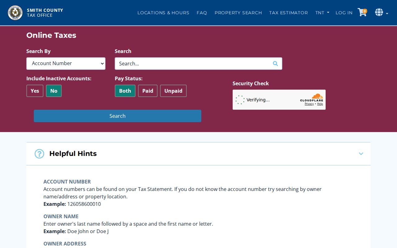
The screen supports a verified-address workflow. It does not support the claim that every address or person in a ZIP can be returned by one official tax query.
Note: A tax account can identify property and an owner mailing field, but it is not a current list of people inside a ZIP.
Check Smith County ZIP Associations
The Texas TREC management-certificate search adds a ZIP-filtered association layer. Its search fields include HOA Name, County, City, ZIP Code, and Association Type. A Smith County filter returned association rows such as Dogwood Park Association, White Tail or Deer Run, Guinn Farms, The Reserve at Lake Tyler, Stonegate West, Tyler Copper Creek, Highland Villas, Deer Haven, and Tyler Oak Creek. The ZIP 75703 view also returned additional association names.
These certificates can provide association and management context. They are not a member roster, and the database warns that the information is user supplied and its completeness or validity cannot be guaranteed. The reserve, subdivision, or postal area named in a result should be checked against the actual parcel before it is used as neighborhood context.
The TREC Smith County certificate results supply the official association-search interface behind this ZIP-focused view.
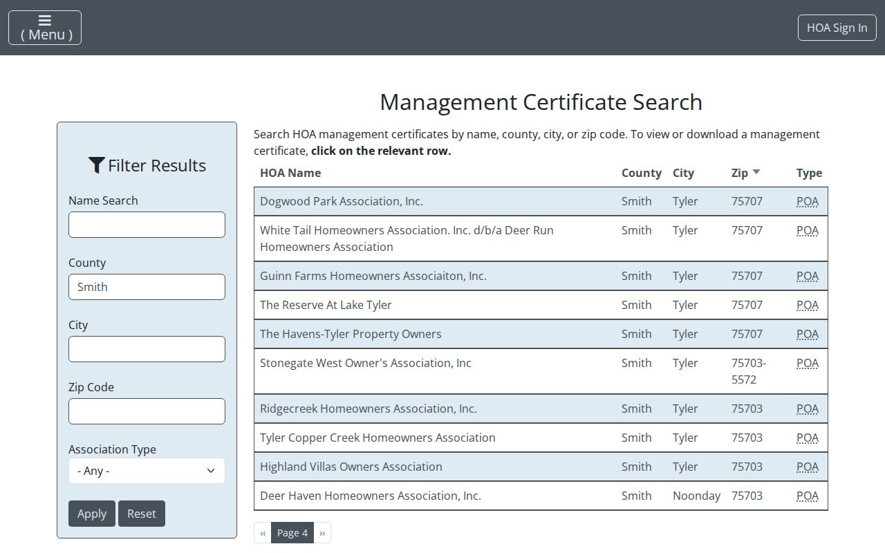
The association filter can help distinguish a community label from a postal area, while still leaving household information private.
Set Smith County ZIP Boundaries
ZIP boundaries and city limits answer different questions. ZIP is a postal routing attribute. A city limit identifies municipal jurisdiction. A legal description identifies the land in a deed, while a situs identifies the physical property location. Smith County includes incorporated and unincorporated pockets, city limits, ETJs, county-controlled subdivision areas, school districts, and postal areas that do not coincide. Tyler’s planning guidance directs address-limit checks to the county map site.
- ZIP code
- A postal routing area. It can cross a municipal or county line and does not establish resident identity.
- ZIP+4
- An added postal detail that USPS returns for a standardized address; it narrows delivery routing but does not prove occupancy.
- PO Box ZIP
- A postal code used for boxes or special service, not a description of the box holder’s physical location.
- Carrier route
- A USPS delivery sequence within an area. It is a mail-routing concept, not a public household directory.
The physical address may be in Tyler’s postal area while the parcel is outside city limits, or an unincorporated address may use a Tyler mailing city. For permit, code, or planning records, follow the map jurisdiction and custody rules instead of the postal label.
Boundary check. A ZIP result can standardize mail delivery but cannot prove city jurisdiction, parcel ownership, or current occupancy. Compare it with the situs, legal description, and map authority.
Check Smith County ZIP History
No official Smith County ZIP split or realignment year was located in the reviewed sources. The USPS Postmaster Finder can help with historical postal questions, but USPS warns that its historical database may contain discontinued or outdated ZIP information. For a current address, the live USPS lookup is the verification route. Do not turn an old ZIP listed in a directory, obituary, or filing into a present postal claim without checking it.
Historical geography can explain an older community or road name without proving a current address. The August 2025 Smith County Historical Atlas update described landmarks, historic routes, more than 200 cemeteries, and popup records with photos or documents. That context is useful when a postal city, rural route, or neighborhood label has changed around a parcel.
Note: Record the date of every postal result, because a current standardized ZIP and a historical mailing reference can both be accurate for different times.