
Smith County Neighbor Record Sources
Nearby properties are best researched parcel by parcel. The map establishes which parcels directly adjoin the subject property. Tax and appraisal entries identify an owner of record, a property location, and sometimes a mailing destination. The deed index adds recorded parties and legal descriptions. Association certificates and historical files add a community layer, but neither creates a public household roster. Start with the official source that matches the question, then state only what that source actually supports.
| Source | What It Shows About a Block | Access |
|---|---|---|
| SCAD or county parcel map | Parcel outlines, roads, adjacent parcel links, and subdivision context | Public map; boundaries are approximate and not a survey. |
| Tax or appraisal account | Owner of record, situs, mailing destination, account status, and exemption indicators | Search each parcel individually; it is not an occupancy list. |
| County Clerk deed index | Recorded parties, instrument date, document number, and legal-description chain | Online index; copies or older material may require payment or office access. |
| Texas voter sources | Individual registration status or an official county or precinct extract | Public and confidential fields are controlled by state law. |
| HOA or POA certificates | Association, county, city, ZIP, type, and management-contact lead | Official TREC association search; no member roster is verified. |
| Criss-cross directories | Historical street or household entries and telephone listings | Appointment and manual research; incomplete and not current. |
An owner, an occupant, and a household member are different facts. A parcel account supports a recorded ownership claim. A homestead indicator can be a clue about an owner’s residence exemption, but it is not a daily count of the people at the address.
Smith County Parcel Edges
The Smith County Map Site and SCAD interactive map are the starting points for an immediate-block search. Locate the known address, zoom to the street scale, click the subject polygon, and note each directly adjoining parcel ID. Record the road or right-of-way boundary, subdivision, lot and block, legal description, owner of record, and date retrieved. If the map exposes a property link for an adjoining polygon, use the linked account rather than guessing from map labels.
The research did not verify a dedicated buffer, radius, measure, or one-click neighbor-report tool in the public map. Do not assume one exists. Map lines are approximate and do not replace a survey. The parcel’s legal description is the durable connection when a street address has changed or an account has been split, merged, or renumbered. Zoning and district layers can provide local context, but they do not identify residents.
Note: Keep the subject parcel and every adjoining parcel in a dated working table so later deed or tax findings can be traced to the right polygon.
Smith County Voter File Limits
Texas My Voter Portal is a person and registration lookup, not a public block map. It accepts a VUID, a Texas driver-license number when supplied during registration, or a first and last name. A full voter-file request uses the Secretary of State’s public-information form for county or precinct extracts and carries its own affidavit, delivery, deposit, payment, and data-handling requirements. It should never be treated as permission to create or publish a street-by-street list.
Election Code sections 13.004 and 18.005 make some fields public under the statutory scheme, including name, date of birth, VUID, and elections participated in. Social Security numbers, driver-license and DPS ID numbers, telephone numbers, protected residential addresses, and ballot choices are not public. An address can be omitted or substituted for a protected voter. The immediate block can be researched through parcel records and lawful community contacts without trying to fill those protected gaps.
Smith County HOA Contact Routes
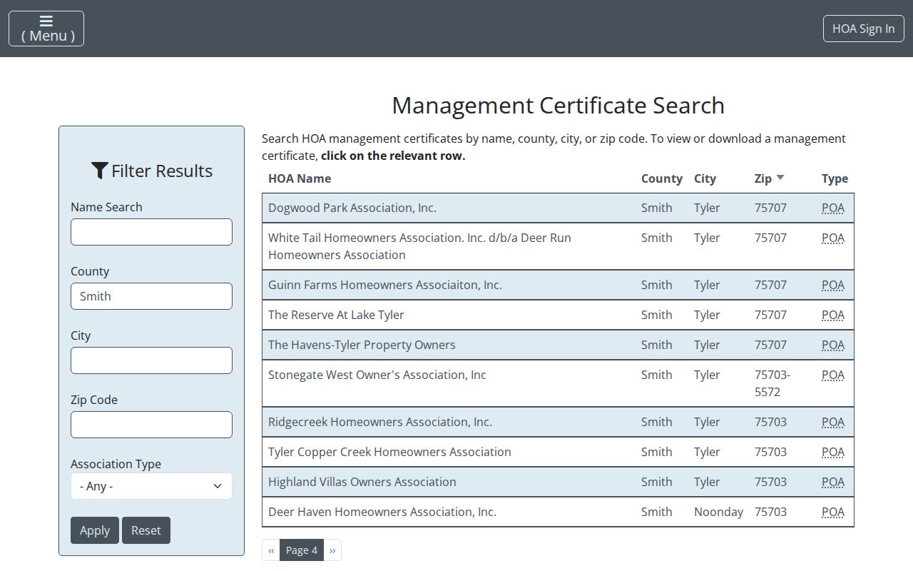
The Texas Real Estate Commission management-certificate search is the official association route for mandatory property-owner associations. It can be searched by HOA name, county, city, ZIP, and association type. The Smith County-filtered results include several association names, but the portal warns that certificates rely on user-provided information and their completeness and validity cannot be guaranteed. Treat a certificate as a way to locate current management contact information, not as a list of people who live there.
| Association or area | Useful public contact context |
|---|---|
| Dogwood Park Association | Smith County TREC certificate row; use the certificate for association-management contact only. |
| White Tail / Deer Run and Guinn Farms | Smith County certificate results; no public member directory was verified. |
| The Reserve at Lake Tyler | Tyler 75707 community with public board context and a member login; a public household list is not established. |
| Stonegate West and Tyler Copper Creek | Tyler-area certificate rows; check the current certificate for management information. |
| Country Place, Holly Square, and Hollycreek Village | Association metadata appears in the ZIP 75703 filtered view; use it as a contact lead only. |
The Smith County-filtered TREC result displays an association-level route, not a source for identifying a household by address.
Where a community site offers a board contact or member login, use the public contact path and respect any member-only boundary.
Smith County Block History Context
Smith County’s new Historical Atlas can add context to an older road, cemetery, community, or neighborhood name. The Commissioners Court update describes a web-based atlas with historic routes, more than 200 cemeteries, landmark entries, popup photos and documents, and public contribution capability. It is not a present-day people directory. Use it to understand why a place name appears in an old deed, map, or local file, then return to parcel or Clerk records for an address-specific fact.
Tyler’s historic and planning resources also name Charnwood, Azalea, Heritage, North End and Texas College area, College Lane, Woodhaven, and Northridge. A historic neighborhood designation is not proof that a homeowners association exists, nor does it identify an address’s residents. The Texas College-area survey work is field research from public rights-of-way and may later add structure history, not a household roster.
Map a Smith County Block
For Smith County neighbors around one address, use a reproducible parcel flow. Begin with the actual property location, then move outward only to parcels that share a boundary or are separated by a road. The process stays focused on the immediate block rather than rebuilding an entire named street’s chain.
- Find the subject address on the Smith County or SCAD map and save the parcel or account reference shown there.
- Click each adjoining polygon and record the parcel ID, legal description, road boundary, and owner link if the map provides one.
- Confirm each account through the SCAD or Tax Assessor-Collector record. Distinguish the physical property location from the owner mailing destination.
- For a recorded-party question, search the owner name and legal description in the County Clerk index. For a full named-street chain, use the Smith County street directory.
This flow can identify nearby parcel records, not every person at a home. Dates matter because parcels, ownership, tax accounts, and mailing destinations can change.
Smith County Neighbor Source Comparison
Official sources preserve the record’s role and date. Commercial neighbor-lookup tools combine public and commercial data into profiles, which can merge same-name people, keep old addresses, omit protected records, or place contact data behind a subscription. A Smith County parcel, deed, or association record is more useful when its custodian and limit remain visible.
| Official Smith County or Texas record | Commercial compiled category |
|---|---|
| Shows a defined record role, such as owner of record, party, voter status, or association certificate. | May combine sources without making each record’s date or original custodian clear. |
| Can be checked with the Clerk, appraisal district, tax office, or state agency. | Can carry stale, duplicated, or same-name information and may offer a separate opt-out path. |
| Retains statutory access limits, redactions, and protected-address rules. | Does not override the limits that apply to official records or confidential addresses. |
Smith County Community Files
The Smith County Historical Society holds house-by-street, church, club, business, cemetery, map, and neighborhood files. Its archive is appointment-only, staff-pulled, and does not allow public browsing or photography. Give staff a street name, approximate year, former owner or occupant, and alternate spellings. The Tyler Public Library adds yearbooks, newspapers, local-history tools, microfilm, and an Ask a Librarian route. These are dated context sources, not a shortcut to current neighborhood identities.
Congregation, civic-club, chamber, and block-watch materials can sometimes supply public event, officer, newsletter, or archival context. Membership rosters may be private or incomplete. Use a published history, public contact, or archive finding aid rather than inferring that every person connected to an organization is a neighbor.
Note: A historical directory or community file can explain an earlier block, but confirm a current parcel fact with a dated official record.
Smith County Neighbor Privacy Limits
Public parcel data does not expose every occupant, and it does not make utility records, delivery data, DMV addresses, private association rosters, sealed cases, or confidential voter addresses available for block research. Texas address confidentiality programs, including the Attorney General and DPS routes, protect qualifying people. A protected voter may have an omitted or substitute address. SCAD’s Internet Opt Out can suppress a name or account from the district website, while public-property access remains governed by the Texas Public Information Act.
Lawful use. Use Smith County neighbor records for personal, lawful research, community context, or reconnecting through an appropriate public contact. Never use information to watch, stalk, harass, intimidate, or harm anyone.